Symonds Yat: the wrong Symonds, a ferry pulled by hand, and the fastest animal alive
A rock 120 metres above a river that bends almost back into itself, a village you cross by rope-pulled ferry because the road takes five miles, peregrines watched through telescopes every summer since 1982, and a cave that held mammoth, hyena and one geologist with dynamite. Symonds Yat, told properly.
whimsee field notes · Symonds Yat Rock · 6 August 2026
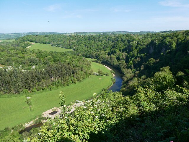
There is a place in the lower Wye gorge where the river, having flowed south with every appearance of purpose, swings east, then north, then west, and ends up a few fields from where it started, facing the way it came. It takes about five miles of water to travel almost nowhere. Above this indecision stands a limestone rock with a car park, a log cabin cafe that has been serving walkers since the 1950s, and one of the most photographed views in Britain. The rock is called Symonds Yat, and nearly everything people tell each other about it on the way up is slightly wrong, starting with the name.
The wrong Symonds. Both of them: where the name really comes from
The story you will hear is that the Yat is named for Robert Symonds, a seventeenth century High Sheriff of Herefordshire. It is a tidy story with a respectable man in it, and the record does not support it. The name is on a Patent Roll of 1256 as Symundesyate, four hundred years before the sheriff, and the scholars read it as an Old English personal name, likely Sigemund, joined to geat, a gate. Sigemund's gate: some early medieval somebody whose whole surviving biography is that a gap in the hills was his.
A yat is a gate, and this one is literally that. The river cuts clean through the ridge, and anything wanting to move through this country, water, roads, a railway at one point, had to file through the same slot.
It gets better. The other famous Symonds of Symonds Yat, the Reverend William Samuel Symonds, whom you will meet further down this page holding dynamite, is no relation to the sheriff and not the source of the name either. Two well documented Symondses. Neither of them the eponym.
The rock with a fort on it
The viewpoint stands about 120 metres above the river, and the ground you queue on to see the bend is a scheduled ancient monument. An Iron Age promontory fort was built here around two and a half thousand years ago, and it was cleverly done: the cliffs defend two sides for free, and the landward approach is barred by lines of bank and ditch that are still there, softened under turf and trees, crossed daily by people carrying coffee.
Stand at the rail and the logic of it assembles itself. The Wye below, the flat green pastures inside the bend at Huntsham, the cliffs opposite, woods running unbroken along the gorge in both directions. Anyone sitting up here could see everything that moved through the gate. That was rather the idea.
The fastest animal alive, on the clock: peregrines from April to August
From April to August there are telescopes at the viewpoint, staffed by volunteers, pointed across the gorge at the cliffs where peregrine falcons nest. In summer the year's young are on the wing, learning the family trade in the air over the river, and the watch is at its best.
A peregrine in a hunting dive is the fastest animal on Earth, and this particular watchpoint has a history worth knowing while you wait your turn at the eyepiece. In the 1950s and 60s the peregrine all but vanished from Britain. Organochlorine pesticides worked their way up the food chain and thinned the shells of their eggs until the eggs broke under the birds that laid them, and the national population fell to a few hundred pairs. The chemicals were banned, slowly, and in 1982 a pair of peregrines came back to the cliffs at Coldwell Rocks, within sight of the viewpoint. Peregrines have held the territory ever since, and the telescopes have been coming out every season for over forty years, which makes this one of the longest running peregrine watches anywhere.
The bird at the eyepiece does not know it is a recovery. It thinks it is simply the management. Goshawks, buzzards, ravens and the odd passing osprey use the same air, so a blank moment at the telescope is rarely blank for long.
Two villages, one river, no bridge: the Symonds Yat hand ferries
Down at the water the place splits in two. Symonds Yat East sits under the Rock on one bank, Symonds Yat West faces it across the river, close enough to read the menu boards on the far side. Driving from one to the other takes about five miles, round by the bridge at Huntsham, which is the sort of fact that rearranges a day when discovered too late.
The river has its own answer, and it is at least five centuries old. Two hand-pulled cable ferries still cross here, one from the Saracens Head Inn on the east bank, one from Ye Old Ferrie Inn on the west, whose building has stood since the fifteenth century. A ferryman hauls the punt across on an overhead cable, hand over hand, the way it has always been done. In 1800 there were said to be twenty five hand ferries working the Wye between Ross and Chepstow. These are the last two. A river that once ran a whole profession is down to a pair of them, pulling visitors between two halves of one village, and the crossing still beats the road by about four and three quarter miles.
The ferries run at the discretion of the inns and of the river. When the Wye comes up in flood the cable stays slack, and you drive.
The rapids that industry left behind
Walk downstream from Symonds Yat East and the river starts to hurry. These are the Symonds Yat rapids, grade 2, busy on any warm day with kayaks practising in the waves, and they are not entirely nature's work.
This stretch was called New Weir, and from the 1590s until 1798 it was an ironworks. A substantial one: three water-powered hammers and a slitting mill, beating and cutting iron in a gorge that now sells ice cream.
The forge closed when its lease ran out. The weir and its lock were pulled down by 1814 and the river moved back in. What the rapids are running over today is partly two centuries of industrial leftovers in the channel, with rock walls on the right bank shaping the waves. In 2003 the national canoeing body bought the banks outright so paddlers would always have access to them.
The bridge that moves on purpose: the Biblins
Keep going upstream from the Rock side, or down from the Biblins campsite, and you come to a wire and timber suspension footbridge that the Forestry Commission strung across the river in 1957.
This is the Biblins, and it wobbles. It's supposed to. Six people at a time, walkers only, and every single one of them grabs the wire and starts grinning at roughly the same point mid-span.
It has taken some punishment. The great Wye flood of February 2020 damaged it badly enough to shut it for months, and it was repaired and open again by that summer. When the river comes up, the bridge closes and waits.
The cave, the hyenas, and the reverend with dynamite: King Arthur's Cave
Up on the Great Doward, the wooded hill above the west bank, is a cave with two entrances and a preposterous name. King Arthur's Cave has no documented connection to any Arthur, but what it does have is better.
In 1871 the Reverend William Samuel Symonds, geologist, and as established above no relation, excavated the cave after miners had begun raiding it. His technique included blasting the stalagmite floor with dynamite, which was how the nineteenth century said "non-invasive survey". Under the floor were bones: lion, giant deer, horse, hyena in quantity, and deeper still woolly rhinoceros, cave bear and mammoth. For long stretches of the Ice Age this was a hyena den, and the gnawed bones of the gorge's grazing herds went down its throat and onto its floor. Stone tools show people sheltered here too, when the Wye Valley was open tundra and the view from the Doward was of reindeer country.
The cave sits now inside a small Herefordshire Wildlife Trust reserve of limestone grassland and woodland, with lesser horseshoe bats occupying the dark the hyenas left behind. No surfaced paths, no barriers worth the name. Go carefully and take a torch you won't need talking into using.
The woods that are found nowhere else
The gorge slopes are part of the Upper Wye Gorge Site of Special Scientific Interest, and that designation is carrying rather more than scenery.
These woods hold nationally rare large-leaved lime. They also hold several whitebeams, unassuming white-backed trees along the cliff edges, which grow in the lower Wye gorge and effectively nowhere else on the planet. One is called White's whitebeam, after a botanist rather than the leaves. A more recently described one carries the river's own name in Latin. Greater and lesser horseshoe bats roost in the caves below, and the peregrines everybody queues for belong to the same designation.
Worth a minute at the rail with that in mind. Everybody comes for the bend, and the bend is the least rare thing in front of you.
If you go
Symonds Yat Rock has a Forestry England pay and display car park, an all-ability path out to the viewpoint, toilets and the log cabin cafe. It fills early in summer. The villages below fill earlier still, and the lanes down to Symonds Yat East are narrow. Come on a weekday, or come early.
The ferries charge a small fare and run in season, when the river allows it. Check before you build a walking loop that depends on one, and keep the Huntsham road in reserve.
The Peregrine Path runs level along the riverside towards Monmouth on the bed of the old Ross to Monmouth railway, and is the gentlest walking here. Paths on Forestry England ground do get closed occasionally for rockfall checks, so a look at their Symonds Yat Rock page before you set off can save you an afternoon.
One plain note, and it is not a joke: the railings at the viewpoint are there because the drop is real, and the crags along the gorge paths are proper cliff edges with trees softening the look of them. Keep to the paths. Keep dogs close on the Doward.
A note on this one
The best part of researching this was watching one man come apart into two. The Symonds who named the Yat and the Symonds who dynamited the cave get merged into a single figure all over the internet, and neither of them turns out to be where the name comes from anyway. The Patent Roll of 1256 settles it: Symundesyate, four hundred years before the sheriff was born.
Two figures are left softer here than you will find them stated elsewhere. The Biblins bridge is widely said to have been refurbished in 1997, and no official source confirms it, so this article says only what Forestry England says: built 1957, damaged in the 2020 flood, repaired. And the height of the Rock appears as both 120 metres and 152 metres, depending where you look. The larger number is the summit's height above sea level rather than above the river, and they are not the same thing.
- When can you see peregrine falcons at Symonds Yat Rock?
- The RSPB watchpoint runs from April to August, with volunteers and telescopes at the viewpoint trained on the nesting cliffs at Coldwell Rocks across the gorge. High summer is when the year's young are flying. Peregrines have held the territory every year since 1982.
- Why is it called Symonds Yat?
- A yat is a gate, from the Old English geat, and the river cuts a gate through the ridge here. The name appears on a Patent Roll of 1256 as Symundesyate, four hundred years before the seventeenth century sheriff Robert Symonds it is usually credited to. Scholars read the first part as the Old English personal name Sigemund.
- How do you get between Symonds Yat East and Symonds Yat West?
- By hand ferry, or by road round via Huntsham bridge, which is about five miles. Two hand-pulled cable ferries still cross the river, one from the Saracens Head Inn on the east bank and one from Ye Old Ferrie Inn on the west. They run in season, at the discretion of the inns and the river, and stop when the Wye is in flood.
- How high is Symonds Yat Rock above the river?
- About 120 metres. The figure of 152 metres that appears in some places is the summit's height above sea level rather than above the river.
- What was found in King Arthur's Cave?
- Ice Age animal bones, in quantity. The Reverend William Samuel Symonds excavated it in 1871 and found lion, giant deer, horse and a great deal of hyena, with woolly rhinoceros, cave bear and mammoth deeper down. It was a hyena den for long stretches of the Ice Age. Stone tools show people sheltered there too.
everything above is checked. if we could not find a source for something, it is not in here.
- Forestry England: Symonds Yat Rock, the hillfort, the raptors and the log cabin
- Historic England: the Iron Age promontory fort at Symonds Yat, list entry 1016760
- RSPB Gloucestershire Local Group: the peregrine watch at Symonds Yat Rock
- BTO BirdFacts: the peregrine, the pesticide crash and the recovery
- The Saracens Head Inn: the hand-pulled ferry, and the twenty five there used to be
- Forestry England: Biblins Bridge, its rules and its floods
- Herefordshire Wildlife Trust: King Arthur's Cave nature reserve
- Symonds Yat (Wikipedia): the 1256 name, the New Weir ironworks and the five mile drive
- Symonds Yat Rapids (Wikipedia): the man-made grade 2 and the 2003 purchase
- Walk Wheel Cycle Trust: the Peregrine Path on the old Ross to Monmouth railway
whimsee is a little app for wandering. people leave small glimmers of wonder in places like this one, and other people go and find them. no feed, no algorithm, just a reason to go outside.
see how it works