The stones of Staunton: a rocking stone, a bleeding stone, and the biggest boulder in Britain
One small village on the edge of the Forest of Dean has a rocking stone that six drunk men toppled in 1885, a roadside standing stone said to bleed if you prick it at midnight, and the largest loose block of stone in England and Wales lying in its woods. A walk round all of them, and the stones you cannot visit.
whimsee field notes · Staunton · 1 August 2026
Staunton is one of the oldest villages in the Forest of Dean, and it tells you its business in its name. Staunton is Old English, stan tun, the stony farmstead: this village has been introducing itself by its rocks for a thousand years and counting. It sits on the Monmouth road with a Grade I listed church thought to date from around 1200, arguably the oldest in the Forest, whose stone pulpit is reached by a spiral staircase hidden inside a pier of the tower, and whose six bells the bellringing clubs travel for. About as many houses as it feels it needs.
What it also has, scattered through the woods around it, is the best collection of enormous, opinionated stones in the Forest. There is even an outcrop called the Toad's Mouth, weathered into a gape, in case anyone arriving was in doubt about the local theme. Some of them people put up. Some of them fell where they lie before there were people to watch. All of them have been argued about, painted, pricked with pins, listened under, or pushed over by drunks, and every one of those stories is true.
The stone they broke
Start with the Buckstone, on the high ground southwest of the village, because it is the cautionary tale the others live under.
For most of its existence the Buckstone was a rocking stone: a big block of Old Red Sandstone balanced so finely on its point that a hand could sway it. People came a long way to do exactly that. When Nelson visited in 1802, going round the Forest that supplied his navy's oak, the village painted the stone white in his honour, which is the kind of thing you do when a famous sailor is coming and your best possession is geological.
Then, on 10 June 1885, a party of five travelling actors and a Monmouth innkeeper climbed up after a long lunch and pushed until the stone went over. It crashed down the slope and broke.
The Crown, which owned it, paid to have the pieces hauled back up the hill, cemented together and pinned with an iron bar. So the Buckstone is still there, and the view from it still runs off into Wales, but it has not rocked since. Local belief says that if you walk round it three times as the sun rises you may be granted a wish. Make it a kind one. The stone has had a difficult century and a half.
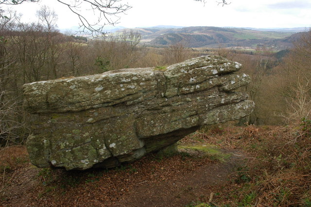
The Buckstone on its ridge, with Wales getting on with things behind it. Photo: Philip Halling, CC BY-SA 2.0, via Geograph.
The stone nobody can weigh
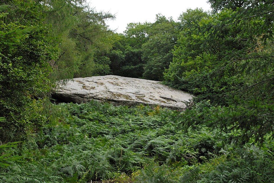
Drop north from the village into Highmeadow Woods and the path brings you to the Suck Stone, which is not standing and never was. It is simply lying there, the way a cathedral would simply lie there, if a cathedral fell out of a hill.
It is a single detached block of quartz conglomerate, puddingstone, around fourteen metres long, and it is reputed to be the largest loose block of stone in England and Wales. How much does it weigh? Fourteen thousand tons, say some estimates. Thirty thousand, say others. The disagreement is instructive: at this scale weighing is not a measurement, it is a guess with a clipboard, and nobody is getting it onto a weighbridge to settle the matter.
How it got here is argued over too. A landslip, says one camp. Ice, says another. There is also a story that a fairy lives underneath it and grants superhuman strength to the right visitor, which would at least explain how anyone expected to move it.
The rock that listens
A little above the Suck Stone stands Near Hearkening Rock, an overhanging cliff of the same sandstone and quartz conglomerate, and the best thing about it is its job title.
The overhang gathers sound. Stand at its foot and the noises of the slope below arrive strangely close: a snapped stick, a voice, a deer moving through. The Forest's gamekeepers knew this and used the rock as a listening post at night, standing in the dark under several hundred tons of stone, waiting to hear a poacher's footstep half a wood away. There is a Far Hearkening Rock about a mile north, because if a thing works, the Forest names it twice.
Try it. Stand still, close your eyes, and listen to a hillside being handed to you by a rock. Then consider that for a couple of centuries, somebody might have been listening to you.
The stone that bleeds
Back on the A4136, about a mile out of the village towards Coleford, a little over two metres of Old Red Sandstone conglomerate stands on end beside the road. This is the Long Stone, and unlike the Suck Stone it did not fall. It was put there, on purpose, probably in the Bronze Age, possibly before 1700 BC, by people whose reasons did not survive them.
The legend attached to it is exact: prick it with a pin at the stroke of midnight and it will bleed. There is, in fact, a rusty red streak running down the back of it. Geology says iron oxide. The legend does not dignify that with a response.
Alfred Watkins put the Long Stone on one of his ley lines in The Old Straight Track, which archaeology has never accepted, and the stone has outlasted the argument the way it outlasts most things.
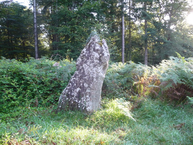
The Long Stone, standing about its business beside the Coleford road. The red streak is round the back, and geology is sticking to its story. Photo: Jeremy Bolwell, CC BY-SA 2.0, via Geograph.
One plain note, and it is not a joke: the A4136 is a fast road and the stone is on its verge. Look at it from a sensible place, and do not reverse a car onto grass to get a photograph of something that has been perfectly still for three thousand years. It will be still next time too.
The map with more on it than the ground
The map is where Staunton stops being a curiosity and becomes a doorway.
Between 2002 and 2011 an archaeologist named Jon Hoyle directed a survey of the Forest of Dean that flew lidar over the woods, a laser scan that sees the shape of the ground through the trees, and the Forest turned out to be full of things nobody had catalogued: around one thousand seven hundred new sites, enclosures, barrows, whole worked landscapes lying under the leaf litter. His book of the survey, Hidden Landscapes of the Forest of Dean, has a map of the Forest's Bronze Age, and it is worth seeking out, because it shows how much company these stones used to keep.
The map has the standing stones on it by name: the Long Stone here at Staunton, the Queen Stone, the Broad Stone, another Long Stone at St Briavels, stones called Cradock and Oudoceus that barely make it onto the internet at all. The Oudoceus Stone sits down on the Wye by Llandogo, the village named for St Oudoceus, a bishop of Llandaff who by legend retired there and died around AD 700: a stone that has spent thirteen centuries wearing a saint's name, which is longer than most saints manage. And around them all, dozens of small squares marking barrow and tump placenames. A tump is a mound, and in this part of the world a mound is very often a Bronze Age burial. Whole fields are named after the dead who were already ancient when the fields got their names. The Forest is a graveyard with trees on it, and the stones are its surviving furniture.
And the map is still growing. In 2019 Hoyle announced a find made while checking the lidar results on the ground near Tidenham: a Bronze Age ring cairn, a circular bank about twenty five metres across, set with at least ten small white standing stones, none of them a metre tall, the first monument of its kind found in Gloucestershire. On the scan he had taken it for a wartime gun emplacement, until he stood in it. It had been there around four thousand years, in a forest people cross daily, waiting for a laser. The stones in this article are the ones that stayed visible. The ground is holding more.
The one that is missing
The map marks a Long Stone at St Briavels, seven miles south. Do not drive there looking for it.
It stood ten feet tall in a field near Closeturf Farm, taller than the Staunton stone, and in 1875 it was destroyed. That is the entire entry. Three thousand years standing in a field, and then the Victorian period happened to it.
It earns its place in this article for one reason: it is what the Buckstone nearly became, and it is why the map matters. A standing stone looks eternal and is actually one bad afternoon from being rubble in a wall. The ones that are left are not the ones that were strongest. They are the ones that got lucky.
The ones you cannot walk to
Two more stones belong to this story, and neither of them should be marched at, so here they are from a respectful distance.
The Queen Stone stands in a great bend of the Wye below Huntsham Hill, near Symonds Yat, on private farmland with no path to it. It is about seven feet tall and deeply strange: grooved from top to bottom with runnels big enough to lay a fist in, worn by water along the softer seams of the stone over more time than the mind holds comfortably.
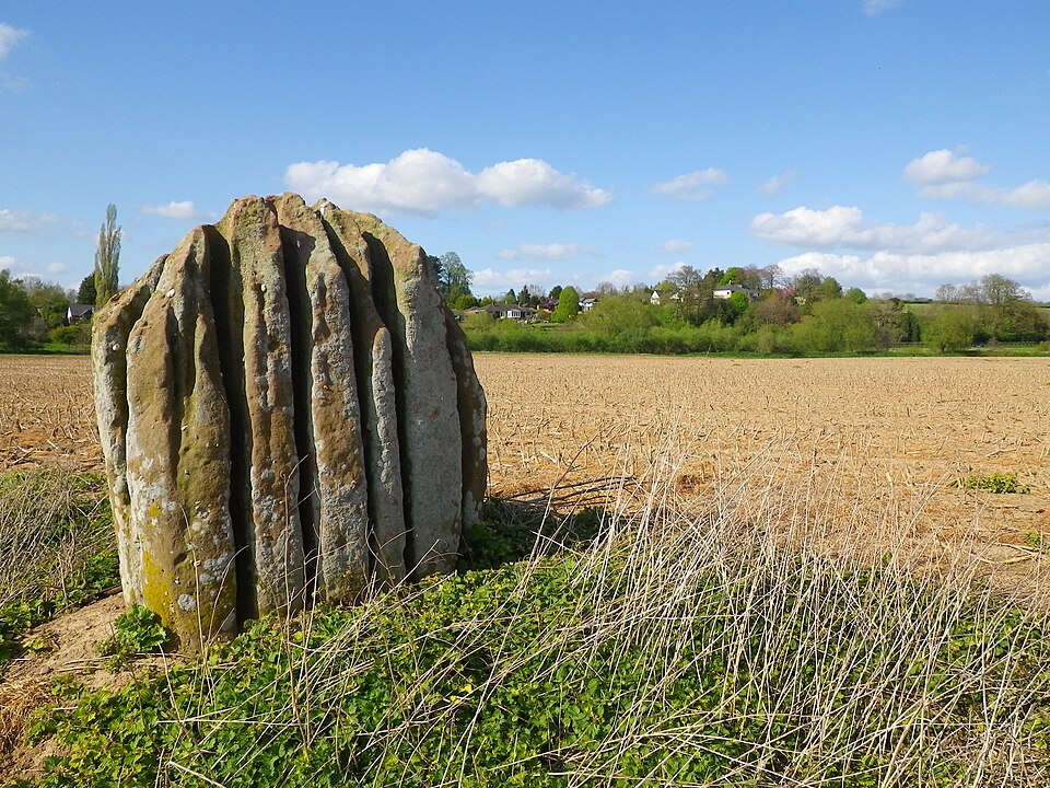
The Queen Stone and its grooves, alone in its field in the bend of the Wye. The photographer's vantage is not an invitation: the field is private farmland, so this picture is the visit. Photo: Speleo 222, CC BY-SA 2.0, via Geograph. Alfred Watkins, whom you met at the Long Stone, could not leave this one alone either: he dug about its base, photographed it for years (Herefordshire's archive has him standing with it in 1933, two old things regarding each other), and argued the grooves were no accident of nature. Received opinion held then and holds now: water, given time enough, needs no help. It is a stone in a field, it is older than every idea anyone has had about it, and it belongs to the farm it stands on, so let it alone and be glad it is there.
The Broad Stone lies the other way entirely, south past the Forest at Stroat, on the flat bank of the Severn between two creeks called Horse Pill and Waldings Pill. It has been called the Broad Stone since at least 1270, and it seems to have marked something worth marking: the landward end of an ancient crossing of the Severn, with a prehistoric trackway traced from the stone across the parish towards the Wye crossing at Brockweir. A signpost, in other words, possibly the oldest working one in Gloucestershire, except the ferry it pointed to has been gone for most of recorded history. Legend prefers a different account, in which the Devil and the local hero Jack o' Kent held a stone throwing contest across the Severn, and this was one of the throws. If you go and look at it, look from the path. The Severn's bank is tidal mud, and tidal Severn mud is not a surface, it is an appetite.
If you go
Staunton is on the A4136 between Monmouth and Coleford. The village walk to the Buckstone, the Suck Stone and Near Hearkening Rock is a genuine circular on waymarked forest paths, and the local tour guides association runs it as a guided walk if you would rather have the stories told to you on the ground. Boots in winter: Highmeadow Woods does mud with real commitment.
Three plain notes, and these ones are not jokes. The Long Stone sits on the verge of a fast road, so view it with care and park somewhere proper. Near Hearkening Rock is an overhang, so enjoy it from the foot rather than the lip. And the Queen Stone is on private land: it is in this article as a thing to know, not a place to go.
Phone signal in the woods is patchy, which is worth knowing before you rely on a map that lives in one.
If you are staying in the Wye Valley
Staunton is barely in England. Monmouth is ten minutes down the hill, the Wye runs just the other side of the ridge, and the Queen Stone's great river bend at Huntsham is the same water you have been photographing from Symonds Yat Rock, which is two miles away and on every itinerary anyway. If you have done the Yat and the river is busy with canoes, the stones are the quiet version of the same morning: the ridge above the gorge, nobody about, and things in the woods a great deal older than the view.
A note on this one
This article exists because of a laminated sheet of paper in a museum. The Dean Heritage Centre at Soudley has a map of the Forest's Bronze Age on display, reproduced from Jon Hoyle's Hidden Landscapes of the Forest of Dean, and it names stones that a week of ordinary searching would never surface. That is what local museums are for, and it is why the sources at the foot of this page include a book as well as links.
Two things nearly got printed wrong. The Suck Stone's weight appears online as both fourteen thousand and thirty thousand tons, stated with equal confidence, so this article commits to neither and says why. And the Long Stone at St Briavels is marked on the Bronze Age map like the others, with nothing to say that it has been gone since 1875; the Victoria County History holds the record of it. A map can be true about the Bronze Age and out of date about last century, which is its own small lesson in reading sources.
One thing was almost too good to be true and turned out to be true anyway. The village's name was checked against the English Place-Name Survey rather than guessed at: stan tun, the stony farmstead. Sometimes etymology simply hands you the article.
other places nearby somebody has already marked in the app.
everything above is checked. if we could not find a source for something, it is not in here.
- Staunton (near Coleford), Wikipedia: the village, the Buckstone, the Suck Stone and the 1885 toppling
- Stonebothering: a journey through the odd stones of Staunton
- The Modern Antiquarian: the Long Stone, Staunton
- Visit Dean Wye: myths and legends of the Forest of Dean
- Victoria County History, St Briavels (British History Online): the Long Stone that stood near Closeturf Farm
- Stroat, Gloucestershire: the Wibdon Broad Stone, named since 1270
- The Modern Antiquarian: the Queen Stone, Huntsham
- Jon Hoyle, Hidden Landscapes of the Forest of Dean (Historic England, 2019): the survey that mapped the Forest's Bronze Age
- Forest of Dean and Wye Valley Tour Guides: the Staunton stones guided walk
- Survey of English Place-Names: Staunton, the stony farmstead
- Historic England: Church of All Saints, Staunton, the Grade I listing
- Archaeology Magazine: the Bronze Age ring cairn the lidar survey found near Tidenham, 2019
- Herefordshire History: Alfred Watkins at the Queen Stone, 1933
- The Church in Wales: St Oudoceus, Llandogo, and the bishop the village is named for
whimsee is a little app for wandering. people leave small glimmers of wonder in places like this one, and other people go and find them. no feed, no algorithm, just a reason to go outside.
see how it works